


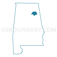
Etowah County PUMA, Alabama
About
Outline

Summary
| Unique Area Identifier | 192089 |
| Name | Etowah County PUMA |
| State | Alabama |
| Area (square miles) | 548.63 |
| Land Area (square miles) | 534.99 |
| Water Area (square miles) | 13.64 |
| % of Land Area | 97.51 |
| % of Water Area | 2.49 |
| Latitude of the Internal Point | 34.04763770 |
| Longtitude of the Internal Point | -86.03442030 |
Maps

Graphs
Select a template below for downloading or customizing gragh for Etowah County PUMA, Alabama


Neighbors
Neighoring Public Use Microdata Area (by Name) Neighboring Public Use Microdata Area on the Map
- Calhoun County PUMA, AL
- DeKalb & Jackson Counties PUMA, AL
- Marshall & Madison (Southeast) Counties--Huntsville City (Far Southeast) PUMA, AL
- St. Clair & Blount Counties PUMA, AL
- Talladega, Cherokee, Randolph, Cleburne & Clay Counties PUMA, AL
Top 10 Neighboring County (by Population) Neighboring County on the Map
- Calhoun County, AL (118,572)
- Etowah County, AL (104,430)
- Marshall County, AL (93,019)
- St. Clair County, AL (83,593)
- DeKalb County, AL (71,109)
- Blount County, AL (57,322)
- Cherokee County, AL (25,989)
Top 10 Neighboring County Subdivision (by Population) Neighboring County Subdivision on the Map
- Gadsden CCD, Etowah County, AL (72,028)
- Albertville-Boaz CCD, Marshall County, AL (37,950)
- Jacksonville CCD, Calhoun County, AL (18,722)
- Oneonta CCD, Blount County, AL (14,908)
- Alexandria-Webster Chapel CCD, Calhoun County, AL (11,730)
- Mountainboro CCD, Etowah County, AL (9,378)
- Hokes Bluff CCD, Etowah County, AL (9,279)
- Crossville CCD, DeKalb County, AL (8,628)
- Ashville CCD, St. Clair County, AL (8,449)
- Centre CCD, Cherokee County, AL (8,252)
Top 10 Neighboring Place (by Population) Neighboring Place on the Map
- Gadsden city, AL (36,856)
- Rainbow City city, AL (9,602)
- Boaz city, AL (9,551)
- Southside city, AL (8,412)
- Attalla city, AL (6,048)
- Glencoe city, AL (5,160)
- Hokes Bluff city, AL (4,286)
- Whitesboro CDP, AL (2,138)
- Carlisle-Rockledge CDP, AL (2,137)
- Sardis City town, AL (1,704)
Top 10 Neighboring Unified School District (by Population) Neighboring Unified School District on the Map
- Etowah County School District, AL (60,417)
- Calhoun County School District, AL (57,392)
- DeKalb County School District, AL (57,097)
- St. Clair County School District, AL (53,540)
- Blount County School District, AL (50,755)
- Marshall County School District, AL (47,197)
- Gadsden City School District, AL (36,856)
- Cherokee County School District, AL (25,989)
- Boaz City School District, AL (9,551)
- Attalla City School District, AL (6,048)
Top 10 Neighboring State Legislative District Lower Chamber (by Population) Neighboring State Legislative District Lower Chamber on the Map
- State House District 26, AL (52,448)
- State House District 34, AL (50,560)
- State House District 40, AL (49,653)
- State House District 39, AL (46,905)
- State House District 30, AL (44,979)
- State House District 29, AL (43,353)
- State House District 28, AL (40,514)
Top 10 Neighboring State Legislative District Upper Chamber (by Population) Neighboring State Legislative District Upper Chamber on the Map
- State Senate District 17, AL (157,178)
- State Senate District 9, AL (144,554)
- State Senate District 12, AL (142,431)
- State Senate District 8, AL (142,128)
- State Senate District 10, AL (125,075)
Top 10 Neighboring 111th Congressional District (by Population) Neighboring 111th Congressional District on the Map
Top 10 Neighboring Census Tract (by Population) Neighboring Census Tract on the Map
- Census Tract 9607, DeKalb County, AL (8,628)
- Census Tract 105.01, Etowah County, AL (8,191)
- Census Tract 501.02, Blount County, AL (7,050)
- Census Tract 310, Marshall County, AL (6,028)
- Census Tract 9558, Cherokee County, AL (5,561)
- Census Tract 102, Etowah County, AL (5,518)
- Census Tract 104.02, Etowah County, AL (5,504)
- Census Tract 312, Marshall County, AL (5,354)
- Census Tract 111, Etowah County, AL (5,302)
- Census Tract 106.01, Etowah County, AL (5,295)
Top 10 Neighboring 5-Digit ZIP Code Tabulation Area (by Population) Neighboring 5-Digit ZIP Code Tabulation Area on the Map
- 36265, AL (21,060)
- 35901, AL (20,045)
- 35903, AL (18,088)
- 35957, AL (15,693)
- 35121, AL (15,570)
- 35904, AL (14,194)
- 36272, AL (13,389)
- 35954, AL (12,416)
- 35960, AL (10,087)
- 35906, AL (9,897)